University of Reading
Type of resources
Topics
Keywords
Contact for the resource
Provided by
Years
Formats
Representation types
Update frequencies
-
Data consist of field spectral reflectance measurements and surface photographs of cyanobacterial soil crusts and other surficial materials in Diamantina National Park, Queensland. Data were collected as part of project NE/K011626/1 (associated with NE/K011464/1) Multiscale Impacts of Cyanobacterial Crusts on Landscape Stability. The reflectance data and associated surface photographs are of biological and physical soil crusts developed on claypan and sand dune surfaces alongside the Diamantina River (specifically on and around Lake Constance pan and Homestead pan. Data were collected and processed by Kevin White and Ian Davenport, using a Spectra Vista Hr1024i spectrometer with a spectralon reference panel. All data were processed using SVC Hr1024i PC Data acquisition software (version 1.6.7 Beta) to remove areas of spectral overlap. Photographs taken using a range of mobile device cameras. All field photographs are in JPEG (jpg) format. Data were collected for the purpose of assessing the ability to remotely sense presence/absence of cyanobacterial soil crusts for mapping purposes. Data are organised into a directory structure based on specific field experiments, each with its own directory structure. Dataset 1: Calcrete Reflectance Spectra, Diamantina National Park. Calcrete exposures are common in Diamantina National Park, forming flat-topped hills known locally as 'Jump-Ups'. Calcretes creat false positives with the commonly used biological soil crust indices from remote sensing data, so field spectra of calcretes were collected to characterise their spectral reflectance to assist with image processing. Dataset 2: Lake Constance Pan Mapping project Field Photographs, Reflectance Spectra and field notes, Lake Constance Clay Pan, Diamantina National Park. This dataset is a repeat survey undertaken in 2015, which revisited sample points first surveyed as part of the so-called 'MAM survey' in 2000. Dataset 3: Solar Radiation Photosynthesis experiment Field Photographs and Reflectance Spectra from three locations in Diamantina National Park, Lake Constance pan, a duneflank site on ‘Crusty Inlet dune’ (where no photosynthesis could be stimulated) and Homestead pan. The Homestead pan experiment was run twice (Winter 2015 and Summer 2016). Dataset 4: Shade netting experiment Spectral Reflectance measurements of a spectralon panel were taken under the shade netting to characterise the transmissivity of the netting at different solar elevation angles. Dataset 5: Photographic cards Spectral reflectance measurements of a set of photographic reference cards, which were included in the frame of all the surface photographs collected for this project. Dataset 6: Mobile Device experiment Field Photographs taken with a range of mobile device cameras (Moto G, Nexus 6 and Samsung Galaxy Note 10.1) and two cameras (Nikon Coolpix P610 and Nikon Coolpix 950 Full Spectrum), and associated reflectance spectra data, for 5 study sites Crusty Inlet Pan Surface, Crusty Inlet Dune North Flank, Lake Constance Pan and Homestead Dune. Dataset 7: Rainfall simulator Spectral reflectance data and associated field notes of sites used in a rainfall simulator/wind tunnel experiment, Lake Constance claypan (which formed part of the associated NERC project NE/K011464/1)
-
2 examples of Integrated Water Vapour Transport (IVT) maps generated using a new algorithm produced from the work done under the Grant. This algorithm has been published and the article can be found here: http://onlinelibrary.wiley.com/doi/10.1029/2012JD018027/abstract
-
This set of data is the second set of impact interviews conducted with the target communities of the BRAVE project. The interviews are transcriptions in Microsoft word. The communities involved in the data collection were from Tomo and Poa in Burkina Faso and Jawani and Tariganga in Ghana. There are 32 interviews from Burkinabe community members, and 23 from the Ghanaian communities. Individuals were selected based on their participation in the BRAVE field activity of the Farmer Voice Radio. The data was collected between October 2019 and February 2020 by the local researchers. This data methodology was built on the initial vulnerability assessments, and include questions around behaviour change and income change based on the BRAVE communities activities of ground water measurement and water management strategies. This data shows behaviour and livelihood change within the communities and due to these activities. This is final qualitative impacts dataset from the BRAVE project. Previous linked data sets include the baseline vulnerability assessments and the first round of impact interviews. BRAVE: Building understanding of climate variability into planning of groundwater supplies from low storage aquifers in Africa BRAVE is a ‘Consortium’ research project is part of the UPGro (Unlocking the Potential of Groundwater for the Poor) programme.
-
This data set consists of sets of qualitative data in the form of vulnerability questionnaires (referred to as tool 1) and interviews (referred to as Tool 2) from 4 communities - 2 in Northern Ghana and 2 in Burkina Faso.
-
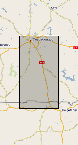
The datasets consist of soil moisture (hourly-weekly), river stage (1 min), and groundwater level (hourly) collected as part of the BRAVE project (NE/M008827/1 and NE/M008983/1) to understand the resilience of boreholes in low-yielding aquifers in the River Volta Basin to climate. The data were collected from physical observatories in Sanon (Burkina Faso) and Aniabisi (Ghana). Soil moisture data were logged hourly beneath contrasting land uses and roaming soil moisture surveys were also undertaken across a wider access tube array. River stage was monitored at the catchment outlet in Sanon and groundwater levels were measured in both catchments.
 BGS Data Catalogue